Solar Compass - History of William Austin Burt's Sun Compass
Compasses that used the angle and length of the sun's shadow to determine the position of the north were used throughout of human history in several forms, ranging from simple techniques used in ancient Greece and Rome to the caved half-discs of Viking sailors that could not only work during the day, but also very reliable (with just a few percent of error) determine the position of the north even up to 45 minutes after the sunset.
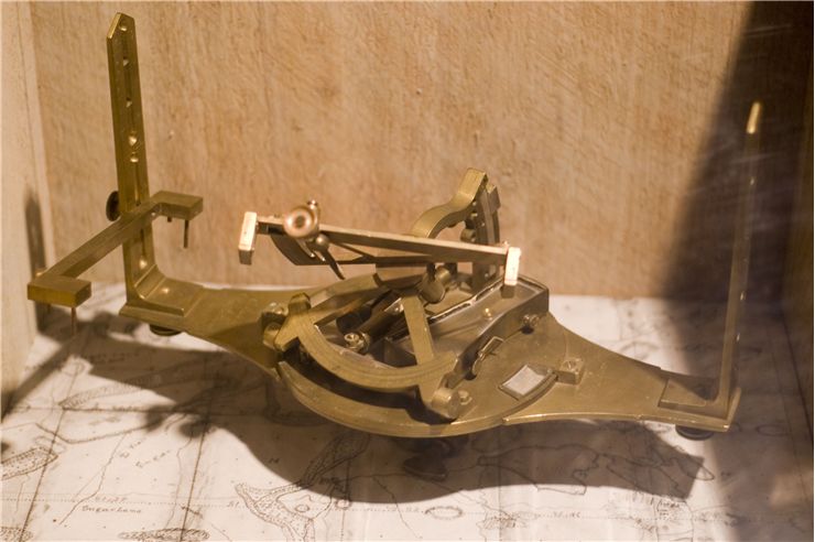
While the invention of the magnetic compass enabled anyone to accurately and easy detect position of the magnetic north, in some situations such compasses created false readings that were influenced by the large deposits of iron ore in the ground. Even if those changes in the direction of the north shown by compass were small, land surveyors faced considerable difficulties in mapping the territories they were tasked to cover which lead to several attempts to create alternative ways of getting reliable orientation readings. One of the most successful and widely praised devices that eliminated the shortcomings of magnetic compass devices was Solar Compass which was invented, built and patented William Austin Burt in 1830s. Creation of this precision device received immediate praise from several world governments and famous astronomical societies, leading to the eventual adoption of the solar compass as the primarily recommended land surveying tool in the United States.
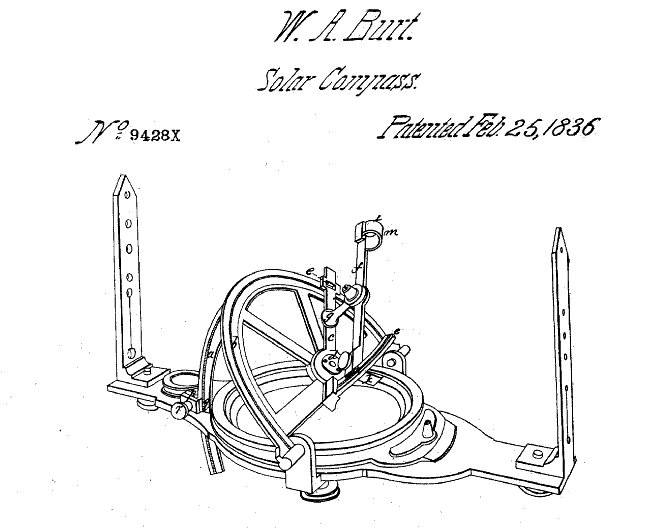
The creation of the first solar compass happened during 1833 when United States Deputy Surveyor William Austin Burt tried to survey unsuccessfully the territory of Michigan that was rich in iron ore. With his magnetic compass readings compromised by the fluctuations in the magnetic field caused by the iron in the ground, he devised device that will (in addition to the data from surveyors transit, measured by precision instrument theodolite) calculate position of true north by measurements of latitude of the land that was to be surveyed, declination of the sun, hour of the day then survey was performed and astronomical charts of the sun's movements (although the same apparatus could be used with tracking of the Moon and stars in the night sky).
The first version of Burt's solar compass was presented to the scientific committee of the Franklin Institute in Philadelphia in 1835, earning him a monetary award and John Legacy Medal for achievement in science. Burt revised and improved his design several times more, presenting his new devices to the Franklin Institute in 1840 and at the Great Exhibition in London in 1851 (which earned him great fame several prize medals from both exhibition holders and astronomical societies). After the patent of William Austin Burt on solar compass expired in 1850, many manufacturers started selling their variations on his device.
While solar compass remained in active use throughout 20th century mostly as terrain surveying tool, it also found application during wartime. The modified small sun compass was developed in 1938 by British Army Lt-Col. James Allason who wanted to eliminated the eliminate the magnetic effects that tanks and other heavy armored vehicles had on magnetic compasses. A few years later during World War II, this compass was not usable during cloudy days on European battlegrounds. However, allied tank divisions in North Africa used sun compass regularly. Today, everyone who owns an analog wrist watch can easily locate north-south line by observing the sun. Simply hold the watch parallel to the ground, point the hour hand toward the sun, and the north-south line will be located directly between the hour hand and the 12 o'clock. In the north hemisphere, North will then be behind the user on that imaginary north-south line on the watch, while in South hemisphere the North will be in front of the user.